
Your How AI is Revolutionizing Ocean Research: Unlocking the Secrets of the Blue Planet
Neil L. Rideout
4/17/20265 min read
How AI is Revolutionizing Ocean Research: Unlocking the Secrets of the Blue Planet
The oceans cover more than 70 percent of Earth's surface, yet we have explored less than 5 percent of their depths in detail. These vast, mysterious waters drive global climate, sustain biodiversity, and support economies worth trillions of dollars through fisheries, shipping, and tourism. Traditional ocean research, however, has long been hampered by extreme conditions: crushing pressures, pitch-black darkness, corrosive saltwater, and the sheer scale of data collection required. Ships and divers can only cover so much ground, and manual analysis of terabytes of footage, sensor readings, and satellite imagery creates massive bottlenecks.
Enter artificial intelligence. In 2026, AI is no longer a futuristic concept in marine science—it is a practical, transformative tool accelerating discovery at unprecedented speeds. From autonomous underwater vehicles that make decisions on the fly to machine-learning models that predict ocean currents with pinpoint accuracy, AI is helping scientists map uncharted seafloors, track elusive marine species, and model climate impacts in real time. This blog explores the key ways AI is reshaping ocean research, drawing on recent breakthroughs from institutions like MBARI, WHOI, NOAA, and global initiatives. The result? Faster insights, smarter conservation, and a deeper understanding of the planet's largest ecosystem.
AI-Powered Exploration: Robots That Think for Themselves
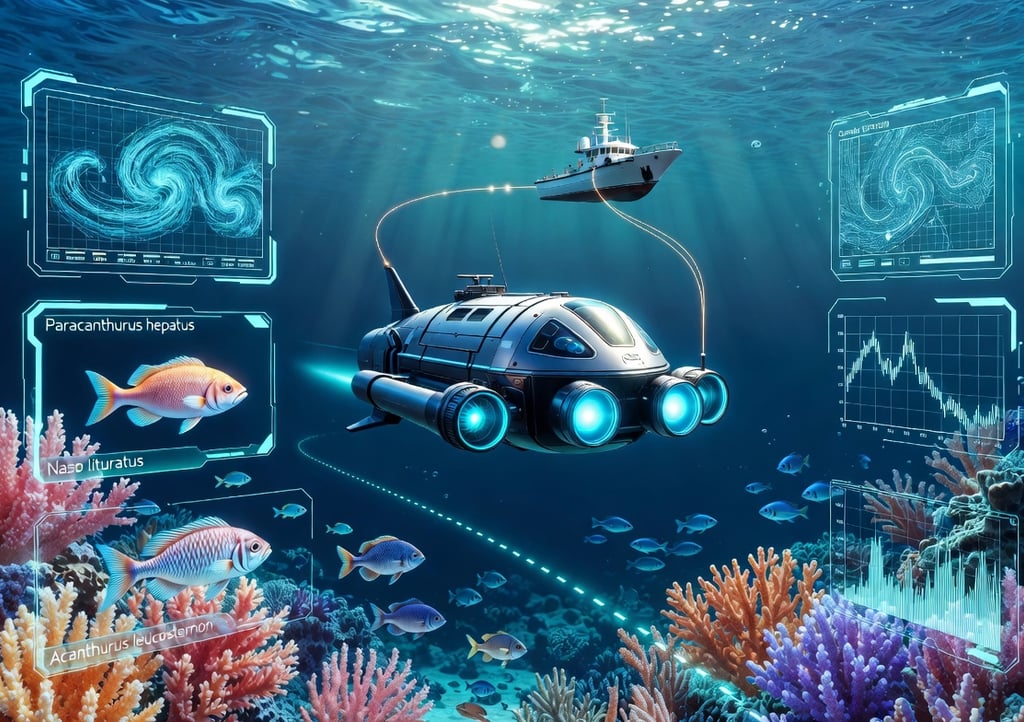
One of the most exciting frontiers is the deployment of AI-enhanced autonomous underwater vehicles (AUVs) and remotely operated vehicles (ROVs). These machines venture into places too dangerous or inaccessible for humans, but until recently, they followed rigid pre-programmed paths. AI changes that by enabling real-time decision-making.
At the Woods Hole Oceanographic Institution (WHOI), engineers have developed AI software like "Spock" that allows vehicles such as the Nereid Under Ice to autonomously select sampling sites along the seafloor. Similarly, the CUREE robot—about the size of a large suitcase—uses computer vision to identify fish, jellyfish, and coral-reef inhabitants on the fly, adapting its path based on what it "sees." During a recent expedition near the Greek island of Santorini, an AI-equipped robot explored the underwater Kolumbo volcano independently, sampling microbes in hazardous zones without human guidance.
MBARI's work takes this further. Their Deployable AI system equips ROVs and AUVs with compact computers and cameras that detect, track, and identify deep-sea animals in real time—fish, jellyfish, siphonophores, and more—using algorithms trained on vast image libraries. This "detector" and "supervisor" approach minimizes human oversight, turning hours of video into actionable science instantly.
These intelligent robots are also tackling seafloor mapping. Reinforcement learning helps AUVs navigate complex terrain without detailed prior maps, while hybrid AI models combine physics-based simulations with deep learning for fluid-structure interactions in harsh marine environments. The outcome is high-resolution data from remote regions, filling critical gaps in our knowledge of deep-ocean ecosystems.
Breaking the Data Bottleneck: From Raw Footage to Insights in Seconds
Ocean research generates enormous volumes of data—satellite imagery, acoustic recordings, environmental DNA (eDNA) samples, and underwater video. The real challenge has always been analysis. A single ROV dive can produce thousands of hours of footage that once required teams of experts to annotate manually.
AI is dismantling this bottleneck. MBARI's FathomNet, an open-source image database co-founded with partners like Ocean Discovery League and CVision AI, uses state-of-the-art machine learning to process visual data at scale. In pilot programs, AI reduced human annotation effort by 81 percent and increased labeling speed tenfold. The companion Ocean Vision AI project, funded by a $5 million NSF grant, integrates these tools into a global platform, allowing researchers worldwide to access processed ocean imagery. A free mobile game called FathomVerse even crowdsources improvements to the models by letting players label real underwater images.
On the satellite side, UC San Diego's GOFLOW system (introduced in April 2026) applies deep learning to thermal images from existing weather satellites. It reveals ocean surface currents in unprecedented detail by recognizing how temperature patterns deform under current flow—no new hardware required.
AI also excels at cleaning noisy data and fusing multiple sources. It separates whale calls from background ocean noise, spots oil spills in vast datasets, and fills gaps in observations by combining satellite, buoy, and glider data. Projects like the European Digital Twin of the Ocean use AI to create "what-if" scenarios, simulating complex climate impacts in seconds.
Monitoring Marine Life: AI Eyes and Ears Underwater
Biodiversity assessment has been transformed by AI's ability to identify species automatically. Computer vision models trained on millions of images now recognize fish, coral, plankton, and even microscopic organisms from underwater footage or drone photos. NOAA Fisheries employs machine learning via the VIAME platform to count seals from aerial imagery and analyze turtle behavior from video, improving population estimates without exhaustive manual review.
Acoustic monitoring benefits too. AI processes years of passive recordings to localize and visualize marine mammal communication, distinguishing protected species calls amid ocean noise.
The Deep Vision project, launched in early 2026 by Plymouth Marine Laboratory and the University of Plymouth, uses AI to analyze thousands of hours of archived seafloor imagery. It aims to map vulnerable marine ecosystems—deep-sea corals, sponges, and xenophyophores—across the entire Atlantic, including high-seas areas beyond national jurisdiction. What once took human analysts months is now completed in days.
These tools extend to real-time monitoring. Crown-of-thorns starfish detection on coral reefs now uses efficient embedded AI models like DCGAN and YOLOv6, enabling rapid response to threats.
Predicting Change: AI as Ocean Forecaster
Climate change is altering oceans faster than ever, with rising temperatures, acidification, and shifting currents. AI-powered predictive models are essential for forecasting these shifts.
Machine learning excels at downscaling global models to regional scales, emulating complex physics, and assimilating data into hybrid systems. OceanPredict's AI Task Team explores these techniques for everything from algal-bloom warnings to carbon-uptake projections.
Global Fishing Watch experiments with AI agents that scan vessel movements via satellite and flag suspicious activity near marine reserves, accelerating enforcement of protected areas. Predictive analytics also support sustainable fisheries by monitoring fish populations and detecting illegal, unreported, and unregulated (IUU) fishing.
In 2026, tools like DeepSea AI, AquaVision AI, and OceanNet are standard in research labs, offering real-time insights into currents, pollution, and ecosystem health.
Conservation Wins and Real-World Impact
AI is directly aiding conservation. By tracking plastic pollution, monitoring coral bleaching, and optimizing marine protected areas, it turns data into actionable policy. Underwater robots equipped with AI now contribute to cleanups, pollution monitoring, and even tsunami detection.
International efforts, including the EU's emerging technologies for ocean observation, highlight AI's role in smarter resource management and autonomous platforms.
Challenges Ahead: Ethics, Access, and Integration
Despite the promise, challenges remain. AI models require massive, diverse training data—bias in datasets can lead to inaccurate predictions in underrepresented regions. Energy demands of AI training raise sustainability questions for ocean research itself. Explainable AI (XAI) and digital twins are emerging to build trust in safety-critical applications like navigation and forecasting.
Access is another hurdle: smaller institutions in developing nations need open-source tools and training to participate fully. Ethical considerations around data privacy, autonomous decision-making in sensitive ecosystems, and the environmental footprint of AI infrastructure must be addressed.
The Future: A Smarter, More Connected Ocean
Looking ahead, AI will integrate even more deeply with robotics, satellite constellations, and citizen science. By 2030, fully autonomous ocean-observing networks could provide continuous, global coverage. Hybrid AI-physics models will refine climate predictions, while gamified platforms like FathomVerse will democratize discovery.
The ocean's future depends on rapid, informed action. AI is not replacing human researchers—it is amplifying their reach, speed, and imagination. From the surface to the abyss, these intelligent systems are helping us finally see the blue planet as the interconnected system it truly is.
As we stand on the cusp of this AI-driven era in oceanography, one thing is clear: the tools to explore, understand, and protect our oceans have never been more powerful. The question is no longer whether AI will help—it already is. Now, it's how we choose to wield it for a healthier, more sustainable ocean.
Contact
Head Office
Green Life Enterprises LLC
7175 E. Camelback Road
Suite 707
Scottsdale, Arizona 85251
greenlifedatacenters@gmail.com
+1-813-220-0001
© 2026. All rights reserved.
Canadian Office
Green Life Enterprises LLC
3142 Nicholson Ave
Suite 10
New Waterford, Nova Scotia B1H 1N8